Anak Krakatau

Crater summit Anak Krakatau.

Anak Krakatau eruption

Strombolian eruption of Anak Krakatau.

Anak Krakatau eruption

Explosive eruption of Anak Krakatau

Ujung Kulon National Park

The Javan Rhinoceros Sondaicus.

Cigenter River Ujung Kulon National Park

Canoeing along Cigenter River searching for The Javan Rhinoceros.

Baduy Tribe

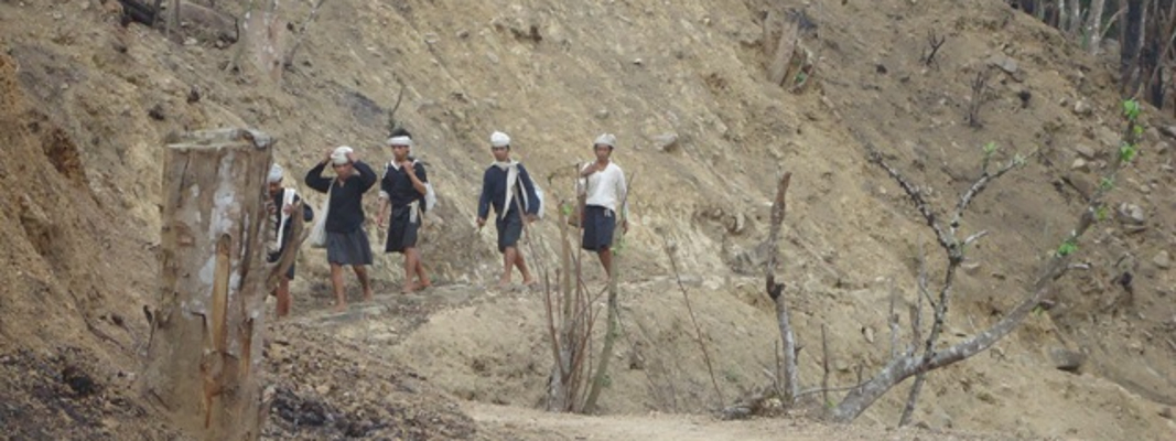
Group of Baduy Tribe traveling on bare foot.

Putri Carita Fall or Little Green Canyon Banten

One of beautiful and excotic waterfall nearby Carita Beach.

Krakatau Camp Tour

Explore Krakatau for two days 1 night by night in the tent.

Krakatau underwater

Explore underwater around Krakatau.

Krakatau and Island surrounding

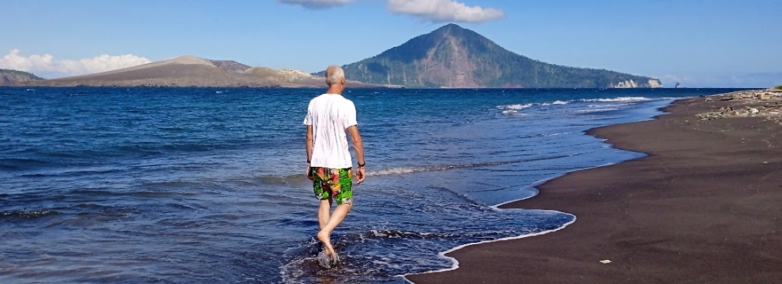
Walking along the beach while seeing an amazing view.

Anak Krakatau

Climbing through the desert to get outer rim.

26 July 2023, Krakatau Tour with Mr Thomas Family

Sunda Strait Indonesia, 26 July 2023
Sailing and Climbing Anak Krakatau
Today the weather is fine but the sea a bit rough, upon arrival at Krakatau we saw that Anak Krakatau just expelled fumarol. So  we then decide to climb.


Peucang Island Day Tour

The unique and delightful island of Peucang lies in clear blue waters off the north western coastline of Ujung Kulon Peninsula. Itswhite sand beaches and coral reff shores hold a fascinating world of marine life while Peucang’s impressive forest shelters an abundance of wildlife, some of which graze and play around the lodges. Opposite Peucang Island across a 800 meters cannel is the Ujng Kulon Peninsula with a wide variety of attractions.
1 / 4
Peucang island
2 / 3
Peucang Island
3 / 3
Peucang Island
4 / 4
Peucang Island

A day Peucang Island Tour Ujung Kulon National Park: Trekking, Wildlife watching and explore underwater around the park.
You will ride a high-powered speedboat to the World Heritage Site Ujung Kulon National Park.

The tour start from Jakarta
Pick up time: 04.00 am

Price from USD 125 per person

What is included
  • Transportation service: Jakarta - Carita Beach (round trip)
  • Hire of private a high-powered speedboat
  • Entry fee to Ujung Kulon
  • Lunch + mineral water + soft drink and fruits
  • Tour at the park
  • Guide
Exclude
  • Travel Insurance
  • Personal expense
  • Local Guide Tip
What to expect
Your host will meet you in Jakarta, then drive to get Carita Beach. Hope the boat, head forward to Ujung Kulon National Park. Explore and trek into Peucang Island forest. Snorkeling nearby the island. Late afternoon, cruising to Carita. Transfer to Jakarta.

Note: 
This itinerary is subject to change due to group abilities and preferences, speedboat availability, weather conditions and forecasts

What you should bring
Some clothes,  small backpack and comfortable trekking shoes for jungle  treks, torch and warm socks, raincoat, plastic or waterproof bag, hut, sunglasses, sun lotion, insect repellent, toilet paper, camera, mobilphone and cards, swimming suit, towel  and personal medicine. 


Visiting and seeing spectacular Krakatau 2D1N Tour.. start from Carita Beach

Krakatau Camp Tour
2 days 1 night

Start from Carita Beach


2 days boat, trek, hike, snorkel and camp around Krakatau. Take a high-powered speedboat cruise the Sunda Strait hike Anak Krakatau and snorkel nearby Rakata Island.

You will ride a high-powered speedboat to the newly formed island (Anak Krakatau). Camp on nearby the island, hike up to view molten of rock and island surrounding.

Price from  USD 150

Include: Hire a high-powered speedboat, Entrance fee to Krakatau, Tent eq, Meals as mentioned at itinerary and Guide

Exclude: All insurance, Extra meals and beverages, Personal expense, All services which are not mentioned on the program, All expenses incurred due to flight cancellation/delay, or due other causes beyond our control

What expect
Day 1
Cruise and afternoon climbing
We'll meet you at your hotel and then hop the boat to get Krakatau. Upon arrival we will set the tent at around Krakatau. Afternoon, We will take some photos from the boat stay closer. If permitted or there is no  eruption, we might be climb the Anak Krakatau.  Tonight you'll enjoy Indonesian dishes.  (L,D)

Day 2
Morning climbing  and explore underwater nearby Krakatau. We then hop the boat return to Carita Beach.

Note: 
  • This itinerary is subject to change due to group abilities and preferences, speedboat availability, weather conditions and forecasts
  • Each of our itineraries can be tailored to your requirements, allowing us to create the perfect holiday just for you. Contact us with your holiday ideas, no matter how big or small, and our destination based teams will start planning a unique and personalized trip.

Anak Krakatau eruption, July 19 2023

Anak Krakatau Volcano Activity updates (Indonesia>Sunda Strait, Banten)

Anak Krakatau Sunda Strait Indonesia, 19 July  2023
Source: Magma Indonesia 
Time: 12.00 - 18.00
Eruption: 11 times
Amplitude: 24 - 40 mm
Duration: 34 - 104 second

July 19th 2023
Eruption with volcanic ash cloud at 0122 UTC (0822 local).
Best estimate of ash-cloud top is around 5302 FT (1657 M) above sea level or 4800 FT (1500 M) above summit. May be higher than what can be observed clearly. Source of height data: ground observer.
Ash cloud moving to southeast. Volcanic ash is observed to be white to gray. The intensity of volcanic ash is observed to be thick.
Eruption recorded on seismogram with maximum amplitude 70 mm and maximum duration 182 second. Generated from Volcanic Eruption Notice (VEN) 
Source: Magma Indonesia

Krakatau Day Tour start from Carita Beach

A day boat, cruise, hike and snorkel around Krakatau. Take a high-powered speedboat cruise the Sunda Strait hike Anak Krakatau and snorkel nearby Rakata Island. You will ride a high-powered speedboat to the newly formed island (Anak Krakatau). Hike up to view molten of rock and island surrounding. 
By a high-powered speedboat

Price from USD 100 

what is included: Hire of private a high-powered speedboat, Entry fee to Krakatau,  Meals as mentioned at itinerary,  Guide 

Exclude:  All insurance,  Extra meals and beverages,  Personal expense All services which are not mentioned on the program,  All expenses incurred due to flight cancellation/delay, or due other causes beyond our control 

What to expect 
Cruise, Hike and Snorkel nearby Krakatau


After you had breakfast, we will pick you up at your hotel and then we get on the boat (cruising) the Sunda strait to the famous, deserted, active volcano island, to see is left of the biggest explosion ever recorded in history mankind (1883) approximately 1,5 hours. Go ashore at Anak Krakatau Beach, we'll hike to get outer rim and breathaking view landscape surrounding. Explore underwater around Krakatau.  Lunch will be served.  Late afternoon sail back to Carita . (L)

Activities: cruising, trekking, climbing up, swimming and snorkeling

Note: This itinerary is subject to change due to group abilities and preferences, speedboat availability, weather conditions and forecasts

Similiar trip

A day boat, cruise, trek and snorkel around Krakatau. Take a high-powered speedboat cruise the Sunda Strait hike Anak Krakatau and snorkel nearby Rakata Island. More info


Discover and explore National Park In Indonesia

1. Mt Rinjani National Park, West Nusa Tenggara Indonesia
Mount Rinjani is very famous for its amazingly beautiful breathaking view. Especially Segara Anak Lake and as well as Mount Batu Jari which is more often referred to as Mount Anak Rinjani.


2. Mt Gede Pangarango National Park, West Java Indonesia
Mount Gede Pangrango National Park is a national park in West Java, Indonesia. The park is centred on two volcanoes—Mount Gede and Mount Pangrango—and is 150 km² in area.
It evolved from already existing conservation areas, such as Cibodas Botanical Gardens, Cimungkat Nature Reserve, Situgunung Recreational Park and Mount Gede Pangrango Nature Reserve, and has been the site of important biological and conservation research over the last century.In 1977 UNESCO declared it part of the World Network of Biosphere Reserves.


3. Bromo Tengger Semeru National Park, East Java Indonesia
Bromo Tengger Semeru National Park (Indonesian: Taman Nasional Bromo Tengger Semeru; abbreviated as TNBTS) is a national park located in East Java, Indonesia, to the east of Malang and Lumajang, to the south of Pasuruan and Probolinggo, and to the southeast of Surabaya, the capital of East Java. It is the only conservation area in Indonesia that has a sand sea, the Tengger Sand Sea (Indonesian: Laut Pasir Tengger), across which is the caldera of an ancient volcano (Tengger) from which four new volcanic cones have emerged. This unique feature covers a total area of 5,250 hectares at an altitude of about 2,100 meters (6,900 ft). The massif also contains the highest mountain in Java, Mount Semeru (3,676 meters (12,060 ft)), four lakes and 50 rivers. It is named after the Tengger tribe. The explosion of the volcano that created the caldera, happened ca. 45.000 years ago, in an event similar to the Krakatau eruption.


4. Komodo National Park, East Nusa Tenggara Indonesia
Komodo National Park is a national park in Indonesia located within the Lesser Sunda Islands in the border region between the provinces of East Nusa Tenggara and West Nusa Tenggara. The park includes the three larger islands Komodo, Padar and Rinca, and 26 smaller ones, with a total area of 1,733 km2 (603 km2 of it land). The national park was founded in 1980 to protect the Komodo dragon, the world's largest lizard. Later it was dedicated to protecting other species, including marine species. In 1991 the national park was declared a UNESCO World Heritage Site.
Komodo National Park has been selected as one of the New7Wonders of Nature. The waters surrounding Komodo island contain rich marine biodiversity. Komodo islands is also a part of the Coral Triangle, which contains some of the richest marine biodiversity on Earth.

5. Ujung Kulon National Park, Banten Indonesia
Ujung Kulon National Park is a national park at the westernmost tip of Java, in Banten province of Indonesia. It once included the volcanic island group of Krakatoa in Lampung province,although current maps suggest the Krakatoa island group as its own protected area, the Pulau Anak Krakatau Marine Nature Reserve.


6. Bunaken National Park
Bunaken National Park is a marine park in the north of Sulawesi island, Indonesia. The park is located near the centre of the Coral Triangle, providing habitat to 390 species of coral as well as many fish, mollusc, reptile and marine mammal species. The park is representative of Indonesian tropical water ecosystems, consisting of seagrass plain, coral reef, and coastal ecosystems.
It was established as a national park in 1991 and is among the first of Indonesia's growing system of marine parks. It covers a total area of 890.65 km², 97% of which is marine habitat. The remaining 3% of the park is terrestrial, including the five islands of Bunaken, Manado Tua, Mantehage, Nain and Siladen. The southern part of the Park covers part of the Tanjung Kelapa coast.


Anak Krakatau eruption

News about: Anak Krakatau Volcano Activity updates (Indonesia>Sunda Strait, Banten)
Sunda Strait Indonesia, 19 June  2023
Source: Anak Krakatau Volcano Observatory 


  • Eruption with volcanic ash cloud at 0122 UTC (0822 local).
  • Best estimate of ash-cloud top is around 5302 FT (1657 M) above sea level or 4800 FT (1500 M) above summit. May be higher than what can be observed clearly. Source of height data: ground observer.
  • Eruption recorded on seismogram with maximum amplitude 70 mm and maximum duration 182 second. Generated from Volcanic Eruption Notice (VEN)


Where is Krakatau

Krakatau is a  volcanic island in Indonesia, located about 50 KM west Coast of Banten . In August 1883, the eruption of the main island of krakatau (or Krakatau) killed more than 36,000 people, making it one of the most devastating volcanic eruptions in human history.


Where Is krakatau?

The volcanic island known as krakatau is located in the Sunda Strait, between the islands of Java and Sumatra. At the time of its famous eruption in 1883, the region was part of the Dutch East Indies; it’s now part of Indonesia.

A previous major eruption, likely in the fifth or sixth century A.D., is thought to have created krakatau and two nearby islands, Lang and Verlatan, as well as the undersea caldera (volcanic crater) between them.

By 1883, krakatau was made up of three peaks: Perboewatan, the northernmost and most active; Danan in the middle; and the largest, Rakata, which formed the southern end of the island.

krakatau was last thought to have erupted some two centuries earlier, in 1680, and most people believed it was extinct. But in May 1883, people reported feeling tremors and hearing explosions, first in western Java and then on the other side of the Sunda Strait in Sumatra.

Reports started coming in from ships sailing through the busy waterway, including the German warship Elizabeth, whose captain reported seeing a cloud of ash above krakatau stretching some 6 miles high. Things had quieted down by the end of the month, though smoke and ash continued to emerge from Perboewatan crater.


krakatau Eruption

Around 1 p.m. on August 26, a volcanic blast sent a cloud of gas and debris some 15 miles into the air above Perboewatan.

It would be the first in a series of increasingly powerful explosions over the next 21 hours, culminating in a gigantic blast around 10 am on August 27 that propelled ash some 50 miles into the air and could be heard as far away as Perth, Australia (a distance of some 2,800 miles).

About 9 square miles of the island, including both Perboewatan and Danan, plunged underwater into the caldera to a depth of some 820 feet below sea level.

krakatau’s violent eruption killed more than 36,000 people. Relatively few of the victims were killed by the tephra (volcanic rock) and hot volcanic gases produced by the blasts themselves.

But tens of thousands more people drowned in the series of tsunamis caused by the volcano’s collapse into the caldera, including a 120-foot-high wall of water that formed just after the climactic blast and wiped out 165 coastal villages on Java and Sumatra.

As evidence of the tsunami’s devastating power, water deposited the steamship Berouw nearly a mile inland on Sumatra, killing all its crew members.


What Caused the Eruption?

Like all volcanic eruptions, krakatau’s can be traced to the movement of the tectonic plates that make up the Earth’s crust, which are constantly moving against each other over the thick liquid layer, or mantle, beneath.

Indonesia is located at the heart of a so-called subduction zone, where the Indo-Australian Plate collides with part of the Asian Plate (Sumatra) as it moves northward.

As a heavier oceanic plate, the Indo-Australian slides underneath the lighter, thicker continental plate (Sumatra), and the rock and other materials that slide with it heat up as it dives below the Earth’s surface. Molten rock (or magma) from below rushes upward through this channel, forming a volcano.

In 1883, each of the three distinct peaks of krakatau served as an exit route for the enormous magma chamber deep below it. Analysis suggests that during an earlier eruption, debris clogged the neck of Perboewatan, and pressure then built up below the blockage.

After the initial explosion split the magma chamber, and the volcano began to collapse, seawater came into contact with the hot lava, creating a cushion of explosively hot steam that carried the lava flows up to 25 miles at speeds of up to 62 mph.


Global Impact of krakatau

The 1883 krakatau eruption measured a 6 on the Volcanic Explosivity Index (VEI), with a force of 200 megatons of TNT. By comparison, the bomb that destroyed the Japanese city of Hiroshima in 1945 had a force of 20 kilotons, or nearly 10,000 times less power.

krakatau’s eruption sent six cubic miles of rock, ash, dust and debris into the atmosphere, darkening the skies and producing vividly colored sunsets and other spectacular effects around the world.

Writing from England, poet Gerard Manley Hopkins described skies of green, blue, gold and purple, “… more like inflamed flesh than the lucid reds of ordinary sunsets … the glow is intense; that is what strikes everyone; it has prolonged the daylight, and optically changed the season; it bathes the whole sky, it is mistaken for the reflection of a great fire.”

Dense clouds immediately lowered temperatures in the immediate area. As the dust spread, according to later studies, the eruption likely caused a drop in average global temperatures for several years.

Other climatic changes occurred thousands of miles from Indonesia: The amount of rainfall in Los Angeles – 38.18 inches – in the months following the krakatau eruption remains the city’s highest annual rainfall on record.

Though krakatau’s is far from the most powerful volcanic eruption in history (the eruption of nearby Tambora in 1815, for example, measured a 7 on the VEI), it’s arguably the most famous. Its 1883 eruption became the first truly global catastrophe, thanks to the recently installed worldwide telegraphic network, which instantly broadcast news of the eruption all over the world.


Krakatau Today

In late 1927, krakatau reawakened, producing steam and debris. In early 1928, the rim of a new cone appeared above sea level, and it grew into a small island within a year.

Called Anak krakatau (“child of krakatau”), the island has continued to grow to an elevation of some 2,667 feet, and erupts mildly at times.

Krakatau, 27 September 2018. Watching the Anak Krakatau eruption from Rakata Island

 Krakatau, 27 August 2018


Anak Krakatau eruption on December 17th 2018

Upon arrival around Krakatau that we saw Anak Krakatau was still erupting continously since June 2018. And finally four days later Anak Krakatau erupted massively caused lanslide and generated tsunami.