Anak Krakatau

Crater summit Anak Krakatau.

Anak Krakatau eruption

Strombolian eruption of Anak Krakatau.

Anak Krakatau eruption

Explosive eruption of Anak Krakatau

Ujung Kulon National Park

The Javan Rhinoceros Sondaicus.

Cigenter River Ujung Kulon National Park

Canoeing along Cigenter River searching for The Javan Rhinoceros.

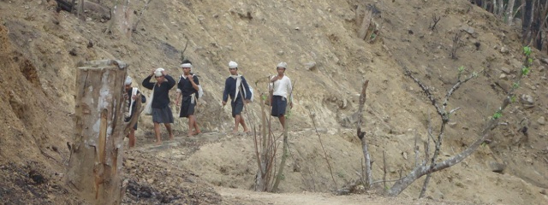
Baduy Tribe

Group of Baduy Tribe traveling on bare foot.

Putri Carita Fall or Little Green Canyon Banten

One of beautiful and excotic waterfall nearby Carita Beach.

Krakatau Camp Tour

Explore Krakatau for two days 1 night by night in the tent.

Krakatau underwater

Explore underwater around Krakatau.

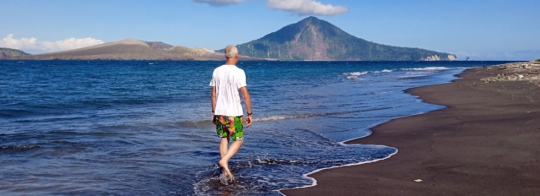
Krakatau and Island surrounding

Walking along the beach while seeing an amazing view.

Anak Krakatau

Climbing through the desert to get outer rim.

Powerful eruption of Anak Krakatau

Sunda Strait Indonesia, 5th September 2026


Plumes of ash and volcanic gases from Anak Krakatau drift over Indonesia and the Indian Ocean in this image captured by the VIIRS (Visible Infrared Imaging Radiometer Suite) on the Suomi NPP satellite on September 5, 2026.

NASA Earth Observatory/Michala Garrison

 A powerful eruption from the Indonesian volcano lofted ash into the atmosphere, disrupting thousands of flights and degrading air quality.

Eruptions are a regular occurrence at Anak Krakatau, a small volcano between the Indonesian islands of Java and Sumatra. Much of its activity remains relatively mild, but it occasionally puts on more impressive and hazardous shows of force. In early September 2026, a booming eruption lasting more than 24 hours sent gas and ash high into the atmosphere, disrupting thousands of flights and degrading air quality in parts of the country, including the capital city of Jakarta.

Satellites passing over the area during the eruption on September 5 captured images of the explosive activity. In the scene above, acquired with the OLI (Operational Land Imager) on the NASA-USGS Landsat 8 satellite, a white plume of volcanic gas billows over a brown ash cloud. Below, a wider view captured by the VIIRS (Visible Infrared Imaging Radiometer Suite) on the Suomi NPP satellite shows the volcanic material dispersing over a large area.

Indonesia’s meteorological agency reported that ash had reached altitudes up to 6,000 meters (20,000 feet) to the east of the volcano and 15,000 meters (50,000 feet) to the west by September 6. The presence of ash in the atmosphere prompted the temporary closure of eight airports on Java and Sumatra, disrupting nearly 3,000 flights in and out of the area, according to news reports.

Ashfall affected populated areas, particularly to the east of Anak Krakatau in Jakarta and other parts of West Java, the Indonesian Humanitarian Coordination Platform (IHCP) reported. Volcanic ash poses health risks to people and can irritate the respiratory tract, eyes, and skin. However, this air quality hazard differs from the smoke produced by peatland fires elsewhere in the country in terms of particle characteristics, dispersal patterns, and protection measures, the IHCP noted. 

On September 6, the continuous explosive eruption from Anak Krakatau subsided, though the volcano kept rumbling. It returned to a more typical pattern of Strombolian eruptions, characterized by intermittent spurts of ash and volcanic material. Airports had resumed operation by September 8, but the volcano remained at the second-highest alert level on the country’s scale, as it has been since early July.

NASA Earth Observatory images by Michala Garrison, using Landsat data from the U.S. Geological Survey, and VIIRS data from NASA EOSDIS LANCE, GIBS/Worldview, and the Suomi National Polar-orbiting Partnership. Story by Lindsey Doermann.


Anak Krakatau eruption ran nonstop for 25 hours in September 4th, 2026


Image: NASA Earth Observatory/Michala Garrison, using Landsat data from the U.S. Geological Survey


Anak Krakatau eruption ran nonstop for 25 hours in September and sent lava down the island’s western flanks
The Anak Krakatau eruption that began at 11:07 p.m. local time on Friday, September 4, 2026, ran without a break for about 25 hours, until 12:04 a.m. on Sunday, according to Indonesia’s volcano monitoring agency. Satellite images later showed that it had sent lava flows toward the northwest, west and southwest of the vent.
Ash reached up to 50,000 feet (15,000 meters) to the west by September 6, and nearly 3,000 flights in and out of the area were disrupted

Twenty-five hours of eruption
Anak Krakatau, whose name means “child of Krakatau,” rose from the flooded caldera left by the 1883 eruption of Krakatau, the explosion that produced the loudest sound ever recorded.
Indonesia’s Center for Volcanology and Geological Hazard Mitigation, known as PVMBG, had held the volcano at Level III, the second-highest of four alert levels, since July 2, after it detected more volcanic earthquakes and ground deformation. It recorded 224 eruptions between then and September 3.
“Based on our instrumental records, the continuous eruption earthquake episode began to be recorded on Friday, September 4, 2026 at 23.07 WIB and officially stopped on Sunday, September 6, 2026 at 00.04 WIB,” Siti Sumilah Rita Susilawati, the head of PVMBG, told a press conference on September 6.
One more Strombolian blast, lasting about 30 seconds, followed at 3:53 a.m. “We will continue to evaluate the activity level of Anak Krakatau periodically,” she said.
On September 21, the head of the Geological Agency, Lana Saria, announced that the alert had been lowered to Level II and the no-go zone cut from 1.9 miles (3 kilometers) to 1.2 miles (2 kilometers), according to a statement from the Ministry of Energy and Mineral Resources. It did not last. After a new run of eruptions, the agency raised Anak Krakatau back to Level III from 9 p.m. local time on October 9 and widened the exclusion zone to 3.1 miles (5 kilometers) from the eruption center.

Destruction, colonization and stabilization
In the destruction phase, Hikmat said, heat, volcanic ash, toxic gases such as sulfur dioxide and tsunamis can leave the vegetation badly damaged or dead.
“Wildlife is also affected, whether through death, fleeing, or being carried away by waves. However, some animals such as seabirds, bats and flying insects can survive and at the same time act as seed dispersal agents,” he said.
That process, he said, opens the door to primary succession, the term ecologists use for life building a community on new ground that has no soil. Once the surface of the island is covered with sand or volcanic rock, pioneer organisms such as microbes, mosses and fungi begin to appear.
As the ground and conditions change, grasses, bushes, shrubs and small trees can gradually grow and form a young forest. Researchers elsewhere have watched microbes appear just hours after an eruption.
“The process of primary succession can last for decades or even hundreds of years, depending on environmental conditions and the presence of seed dispersal agents,” Hikmat said.

Sand with almost no carbon
Indonesian soil scientists took samples from seven points on the island’s southeast slope in July 2018, and reported in the Jurnal Tanah Tropika that the soil was 98.82 to 99.59 percent sand, with 0.06 to 0.72 percent organic carbon.
In a 1989 paper in Ecological Monographs, Robert J. Whittaker and colleagues compared plant surveys across the Krakatau islands, which the 1883 eruption had sterilized. Their fieldwork took place in 1979, 1983 and 1984.
“On Anak Krakatau, volcanic action has prevented successful colonization away from accreting coastal deposits, and has several times eliminated the entire flora,” the authors wrote, adding that “the major source of propagules for Anak Krakatau is from within the group.”
Another reset came on December 22, 2018. A team led by Thomas R. Walter of the GFZ German Research Centre for Geosciences reported in Nature Communications that a flank collapse cut the island’s height from 1,050 to 390 feet (320 to 120 meters).
“This sector collapse decapitated the cone-shaped edifice and triggered a tsunami that caused 430 fatalities,” Walter and his colleagues wrote.

Ash on crops and the sea
Iskandar, a professor of soil science at IPB University, said on September 7 that ash covering leaves and stems blocks the stomata, the small pores plants use to exchange gases during photosynthesis.
“If the disturbance lasts for days or even weeks, the impact will be bad,” he said in an online interview. “Plants can fail in the flowering process and crops can fail.”
“At relatively close distances, volcanic ash is still quite hot and can cause physical damage. Plants wilt and eventually die,” Iskandar said, adding that rain releases nutrients from the ash “such as calcium (Ca), magnesium (Mg), potassium (K) and others.”
IPB oceanographer Agus Atmadippoera said that “volcanic ash that falls into marine waters does not automatically become a pollutant or poison for the ecosystem. It depends on its intensity and magnitude.”
His colleague Setyo Budi Susilo, of the Department of Marine Science and Technology, added that “the material contains a number of micronutrients, including silica and iron,” which, once stirred by currents, waves and tides, can enrich marine ecosystems.

Caves, cliffs and two small islands
Eruptions also create new habitat, Hikmat said. Lava that cools becomes volcanic rock, which “through weathering can develop into mineral-rich soil,” and lava caves, craters and new cliffs “can become niches for bats, birds, lizards and other organisms,” according to the IPB statement.
On October 2, Susilawati told AFP that “based on an evaluation of Sentinel satellite imagery, two formations resembling small islands can be seen around Mount Anak Krakatau,” one about 2,500 feet (760 meters) to the northwest and the other about 1,620 feet (495 meters) to the southwest. In its October 9 safety recommendations, the Geological Agency placed the new islands in the volcano’s northwest and southeast sectors.
Susilawati said it was too early to call them “children” of Anak Krakatau. In the case of Anak Krakatau itself, she told the agency, several landmasses briefly emerged starting in 1927 and then disappeared due to erosion before an enduring island formed in 1930. Scientists are asking the same kind of question about a possible new island in the Bismarck Sea.
“When an eruption occurs, many animals die from direct exposure to hot lahars and volcanic dust, causing the population to decline significantly,” said Abdul Haris Mustari, a wildlife expert in the same IPB department as Hikmat.
Mustari pointed to the banteng, a wild cattle species, which vanished from the Pananjung Pangandaran Nature Reserve partly because the 1982 eruption of Mount Galunggung buried the grasslands it fed on. He said it can take about 25 to 30 years of regrowth before a forest supports more diverse animal communities.

Experts ask people to let it recover
Because Anak Krakatau is a nature reserve and still volcanically active, Hikmat called for keeping out invasive species, not introducing plants from outside, and monitoring eruptions, tsunamis, vegetation and wildlife over the long term.
“Krakatau is a natural laboratory for the process of primary succession. The task of conservation is not to return nature to what it was, but to protect the natural succession process so that it runs well,” he said.

Limits of what is known so far
The IPB experts spoke about succession and ash in general terms, and their statements do not report new measurements from the island after the 2026 eruption. The soil figures come from samples taken in July 2018, and Whittaker’s plant data from fieldwork in 1979, 1983 and 1984.
Under the current Level III, residents, visitors, tourists and climbers are not allowed to enter or carry out activities within 3.1 miles (5 kilometers) of the eruption center, or within 0.6 miles (1 kilometer) of the new islands in the volcano’s northwest and southeast sectors, according to the Geological Agency’s activity reports on MAGMA Indonesia.
The expert explanation of primary succession at Anak Krakatau was published by IPB University on September 10, 2026.
Monitoring data and recommendations for the volcano are posted by Indonesia’s Geological Agency through its MAGMA Indonesia service.

Source: https://www.ecoticias.com


Ujung Kulon Adventure Tour 3 days 2 nights

Day 01: Jakarta - Peucang Island (Ujung Kulon National Park)

We will pick you up in Jakarta at 5am then transfer to south coast of Sumur village take approx 5 hrs. We will stop of at Carita Beach for having breakfast. Afterward head off Sumur to get the  boat,   cruise to Peucang Island is truly a secluded paradise located at the most western edge of Java Island. Surrounded by a soft white sandy beach, clear blue waters, and enchanting coral reefs, Peucang promises serenity for whoever steps on its sands. and is home to a variety of species of wild animals such as monkeys, hornbills, monitor lizards, wild boars, toucans, sea hawks, and more. The most notable of these is the barking deer that are found abundantly around the island. Arrive check in than we are ready to explore Peucang Island trekking to the Karang Copong ( North of Peucang island ) passes through primary forest. Also you can see kind of huge trees like Ficus or Liana. sometimes we could see common wildlife animals such as; wild pig peacock, hornbill and others.  we then will explorer\ Ciapus coral reef, under water on this area is full of reef also colurfull of tripical fish can find it visit to the world – Among some of the dwellers of Peucang Island underwater realm are butterfly fish, angel fish, clown fish, cockatoo fish, and  more. (B,L,D)

Day 02: Peucang Island - Cidaon grazing ground - Taman Jaya Village

After we had breakfast we will cross by boat  Cidaon grassing ground situated on the peninsula opposite island. Common wildlife to see; wild bull, wild pig, peafowl, leopard, continue cruiser to Taman Jaya Village where the road down the coastline ends, is just outside the park boundary. The village features refreshing atmosphere and calming nature the ancient of Ujung Kulon Rainforest, stop than visit Handeleum Island. The island is surrounded by beautiful mangrove forest, observing some of the wild animals like monkey and deer in its hatural habitat, or just enjoying the view of the place, lies between the group of magrove islands. Boat trip to Cikabembeb river meander through dense overhanging magrove forest. Seeing the beauty of the islands typical mangrove forest.. The habitat of salt water crocodile, type of birds are occasionally sight in this area. The charm of this river lies in its tranquil, primeval beauty, Ujung Kulon was an unbelievably fantastic experience. It’s remarkably peaceful and lovely here, yet full of primeval – mangrove forest and trees that have fallen into the river. The rich colors of the place are so wonderful, and the strong tropical sun creates great pools of mottled light on the river’s surface, than continue to a small Island Just off shore here is a tiny, sandy island, Badul, which is surrounded by a good reef. You dive into the water from about 1 meters. Coral growth around with the variety of both hard and soft corals. Visibility during our snorkeling was less than 3 meters. Schools of bannerfish, angelfish, surgeonfish, clownfish, batfish, butterfly fish and fusiliers inhabit the reef, and we saw some bright nudibranchs. (B,L,D)

Day 03: Taman Jaya Village - Mount Honje range - Jakarta

After we had breakfast  we will  hike across the lush rainforest of Ujung Kulon in this two-four hour morning tour for nature lovers! bring you into the lowland rainforest of Gunung Honje, Here you can observe a multitude of Ujung Kulon wildlife, including exotic flora and fauan. If you’re lucky, you may even come across flying lemurs, mouse deer, javan gibbon, black leaf monkey, wild board, and civets are also found the Rhino occasionally sighted in this region. Back to lodge, we check out  then transfer back to Jakarta. (B,L)

* Itinerary sometimes will change depend on the situation and condition

What you should bring

Light clothes like T-shirts  One small backpack and comfortable boots for jungle  treks (additional sandals for  for explorer & observation treks)  light and warm socks, raincoat, plastic or waterproof bag for your personal belongings, hut, sunglasses, sun lotion, insect repellent, toilet paper, camera, mobilphone and cards, swimming suit and towel personal medical kit and recommended medicine like anti diarrhea medicine, dehydration salt, aspirin and antibiotic

Early warning signals heralded fatal collapse of Krakatau volcano

Early warning signals heralded fatal collapse of Krakatau volcano
By Helmholtz Centre Potsdam


On 22 December 2018, a flank of the Anak Krakatau volcano plunged into the Sunda strait between the Indonesian islands of Sumatra and Java, triggering a tsunami that killed 430 people. An international research team led by Thomas Walter of the German Research Centre for Geosciences GFZ in Potsdam has now shown that the volcano produced clear warning signals before its collapse. This was the result of the analysis of a large amount of data from very different sources collected during ground-based measurements as well as by drones and satellites. Satellite data, for example, showed increased temperatures and ground movement on the southwestern flank months before the catastrophe. Seismic data and low-frequency sound waves from a smaller earthquake two minutes before the sudden collapse of a large part of the volcano had heralded the fatal event. This collapse finally triggered the deadly tsunami. The researchers want to use the analysis of this complex event cascade to improve monitoring and early detection of other volcanoes. Their study was published in the journal Nature Communications.

Volcanic islands like Anak Krakatau often consist of unstable material. Therefore, every now and then a collapse of volcanic flanks occurs on these islands. Yet, this had not been precisely measured until now. "At Krakatau, we were able to observe for the first time how the erosion of such a volcanic flank took place and which signals announced it," Thomas Walter, a volcanologist at the GFZ explains. In their study at Anak Krakatau the researchers were able to show that over months the movement of the southeast flank towards the sea formed a kind of slide. The sudden accelerated slide of the flank into the sea, the so-called flank collapse, lasted only two minutes and was measured by seismographs and infrasound networks before the first impacts of the tsunami had reached the coasts.

"We used an exceptionally broad range of methods: From satellite observation to ground-based seismic data, from infrasound to drone data, from temperature measurements to chemical analysis of eruption products," says Thomas Walter. "Today’s almost unrestricted access to worldwide data was critical in this. In the days following the tsunami, it allowed us to analyse this event at different locations in different countries at the same time.”
Improved monitoring systems as a goal
Similar to Anak Krakatau such events could also herald themselves on other volcanic islands in the Atlantic, Pacific or even in the Mediterranean, to which the results of the study could then presumably be transferred, according to Walter. "We assume that tsunami early warning systems must also take into account events caused by landslides. Those volcanoes that are at risk of slipping should be integrated into the monitoring systems.”
Seismologist Frederik Tilmann from GFZ and Freie Universität Berlin was also involved in the study. He says that the unusual seismic pattern of the flank collapse was a particular challenge when analysing the data. In contrast to tectonic earthquakes, only a small part of this pattern consisted of high frequencies around 1 Hertz (1 oscillation per second). Instead, the earthquake waves contained stronger components in the range of low frequencies up to about 0.03 Hertz (1 oscillation per 35 seconds). "This property was the reason why the event was not detected in any routine evaluation," says Tilmann.
The effort of monitoring systems will pay back, since a large part of the victims of volcanoes in the past two centuries have not been killed by the eruptions themselves, but by landslides and tsunamis, according to Walter. The new results show that the danger of collapsing volcanoes has so far been underestimated. The first step now is to identify the volcanoes at particular risk and to supplement existing measurement methods with additional sensors and new algorithms for evaluation. "We are confident that our findings will lead to the development of improved monitoring systems," said Walter.

Understanding eruptive activity and related hazards at Krakatau volcano

Understanding eruptive activity and related hazards at Krakatau volcano
BGS Research — Volcanoes


When asked what activity is commonly associated with a volcanic eruption, the common response might be lava flows, ash fall, pyroclastic density currents or even lahars, but island volcanoes are susceptible to a much more devastating hazard: tsunamis.
Volcanic tsunamis typically occur when a portion of the volcano collapses or pyroclastic density currents flow into the surrounding water, forming tsunamis that reach many hundreds of kilometres away from the volcano.

Krakatau
One volcano that is commonly thought of when considering tsunamis associated with volcanic activity is Krakatau, in the Sunda Straits in Indonesia: a classic example is the 1883 eruption. Numerous tsunamis formed as material was displaced into the surrounding seas, with the largest inundating large portions of the Sunda Straits, resulting in the deaths of 33 000 people. Despite the magnitude of devastation associated with this eruption, the exact mechanism behind the tsunamis is still not known.

Anak Krakatau
Activity at the Krakatau volcanic complex did not cease following the 1883 event, and, in 1929, Anak Krakatau (the ‘child’ of Krakatau) emerged from the sea. Over the following 90 years, frequent Strombolian eruptions resulted in growth of the volcano. On 22 December 2018, a large portion of the volcano collapsed into the surrounding seas, causing a tsunami that once again impacted large areas of the Sunda Straits, resulting in 437 deaths. The collapse was associated with a large eruption that quickly rebuilt the volcano, obscuring much of the evidence regarding the collapse.

To understand eruptive processes and implications for tsunami initiation at Krakatau. As part of an NSF-NERC project, a team of researchers from the BGS, the University of Birmingham, University College London and the University of Rhode Island are bringing together geological and seismic reflection analysis techniques to better define eruption stratigraphy and volumes of the 1883 event.
This information will inform numerical modelling of the pyroclastic density currents associated with this event, the results of which will in turn be used to initiate numerical tsunami simulations. It is hoped that the insight gained from the study will help identify other volcanoes with the potential for producing tsunamis and to guide our modelling of such events.
We are also part of a NERC Urgency Grant, looking at the 2018 eruptive event to try and understand the relation between the collapse and eruption processes through analysis of satellite imagery, eruption and tsunami deposits and numerical modelling of the eruption plume.
In August 2019, fieldwork was conducted on the islands surrounding Anak Krakatau to identify, analyse and sample deposits from both the 1883 and 2018 events. Grain size, componentry and chemical analysis of these deposits will inform understanding of controls on these eruptions

Krakatau Camp Tour

 Krakatau Camp Tour
2 days boat, trek, hike, snorkel and camp around Krakatau
Take a high-powered speedboat cruise the Sunda Strait hike Anak Krakatau and snorkel nearby Rakata Island.
You will ride a high-powered speedboat to the newly formed island (Anak Krakatau). Camp on nearby the island, hike up to view molten of rock and island surrounding.